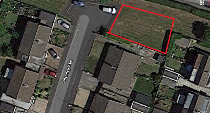
Romsey Avenue Infill Development
- Details
- Last Updated: Thursday, 05 December 2019 17:32
- Hits: 7410

List of Objections to the Development
To help residents object to this development having read the application I will be making the following objections and I would encourage all neighbours who oppose this to do the same.
To view the full planning application click here.
Errors on the Application form.
- Question 4 states the site is 253 sq.metres however the developeable area is considerably smaller 200 sq.metres
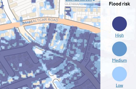
- Question 7 states that the development site is not at risk of flooding however the Environment Agency map shows that the site is at high to moderate risk of surfacewater flooding (Figure 1).
- Question 7 part 2 says the development proposes to discharge surface water to soakaway, however ground conditions here are unsuitable, there is no available watercourse to discharge to, so the only method will have to be public sewer.
- Question 16 on the application form describes the proposal as a 3 bedroom market value house, however the plans are for a 4 bedroom home.

Design and Access Statement.
Page 2 of the Design and Access Statement claims that "National, Regional and Local planning policy has been addressed and fully considered in the development of the proposal for the site". This is not correct because:
Formby and Little Altcar Neighbourhood Plan policy F1 'Avoiding Increased Flooding and Flood Risk' states that "In areas at risk of flooding from any source, developments shall not lead to an increase in flooding or increased flood risk on either the application site or elsewhere within the Plan area. Where reasonably practicable, developers shall demonstrate tangible, definite and measurable reductions in flood risk and actual flooding." The Environment Agency Flood Risk Map clearly identifies this site as at high to moderate risk of surface water flooding however the applicant has not demonstrated that development can occur without flooding to the proposed development or increasing flood risk elsewhere.
The proposed development fails to comply with Sefton Council's newly adopted 'New Housing' Supplementary Planning Document 2018 (SPD) minimum distances between dwellings designed to protect residential amenity. The distance between the rear bedroom of the proposed property and that of the adjacent house is 17m, 4m short of what is required.
The proposal is contrary to Sefton Local Plan Policy EQ2 Design. Development will only be permitted where:
- Part 1(a) The proposal responds positively to the character, local distinctiveness and form of its surroundings.
- Part 2. In relation to site design, layout and access: (b) Integrates well with existing street patterns.
- Part 3. In relation to the design of buildings and structures: (a) Proposals make a positive contribution to their surroundings through the quality of their design in terms of scale, height, form, massing, style, detailing...
Structure too high:
The proposed development of a large two storey 4 bedroom home sits at the end of a row of bungalows. The pitch of the existing properties roofs are much less steep than the proposed development and the new building would have a significantly higher ridgeline than its neighbours’ should the development to go ahead.
Scale and style of to the development overbearing:
The scale and form of the building with an additional gable on the front facade is overbearing and dominates the street scene. The choice of black aluminium window frames, doors and ‘k-render’ dormers will give extra emphasis to the substantially greater volume of this building compared to its modest neighbours.
Loss of amenity Gardens overlooked and overshadowed.
The side and rear elevation will dominate the view from rear gardens of the near neighbours as the building juts out beyond the rear building line and the three adjoining gardens will be significantly overlooked. Sefton New Housing SPD requires a distance of 10.5m from the new dwelling to the rear fence to avoid loss of amenity from overlooking, this development only provides 7m.
Parking provision insufficient for the size of development and incompatible with the street scene.
The existing bungalows, with which the proposal seeks to fit in, all have parking to the side of the properties and not directly in front, unlike the proposed design. Document DC_2019_02117-LOCATION__SITE_AND_PROPOSED_PLAN__01_-2076660.pdf shows parking across the front of the doorway, side on to the street scene which is out of character with the neighbouring properties. Two spaces are required as specified in Formby and Little Altcar Neighbourhood Plan Policy H6: Off-Road Parking: All new dwellings must provide off-road parking spaces and those of 2 bedrooms and above must provide off-road parking for at least 2 cars. The Department Of Transport (DoT) Manual for Streets sets a minimum parking space as 4.2m by 2.4m however many family car lengths are in excess of 4.5m and Multi Purpose Vehicles (MPV ‘People Carriers’) are often over 5m long. Sports Utility vehicles (SUV’s) are similarly around 5m long. As the property is clearly appropriate for a larger family, greater provision is necessary to provide a practical place for parking. Even at its widest, the area in front of the proposed development may leave less than a metre clearance between car and house/window when parking a larger family vehicle. At its narrowest the front curtilage of the development is not deep enough for the minimum required DoT 4.2m long parking space.
More errors in the Design Statement.
Page 3 paragraph 2 of the Design and Access Statement is misleading, incorrectly describing the proposal as a 3 bedroom detached dwelling when it is in fact a 4 bed detached home.
Level access unsiutable for flood risk areas.
Page 4 paragraph 2 says “The proposed landscaping for the access driveway will be paving sets to the front drive way area, suitable for wheelchair users and with level access to the front entrance and to the garden area”. However given the risk of surface water flooding in order to protect the property from surface water this may require an elevated finished floor level, potentially raising the ridge height of the property still further. Raising the surrounding ground level to allow for a level access will increase the likelihood of flooding elsewhere. This again is contrary to policy EQ8 of Sefton’s Local Plan and Policy F1 of Formby and Little Altcar Neighbourhood Plan.
National Planning Policy Framework Chapter 12 Achieving well-designed places para 130 says that “Permission should be refused for development of poor design that fails to take the opportunities available for improving the character and quality of an area and the way it functions, taking into account any local design standards or style guides in plans or supplementary planning documents”.
In summary and for the reasons above this planning application is contrary to:
Nation Policy NPPF 2019 paragraph 130.
Sefton Local Plan Policies EQ 2 ‘Design’ and EQ 8 ‘Flood Risk and Surface Water’
Formby and Little Altcar Neighbourhood Plan Policy F1 Flooding and H6 ‘Off Road Parking’.
Sefton SPD 'New Housing'.
How to Submit your objections.
You can object by post. If so please quote the Planning Application reference DC/2019/02117 and send to:
Planning Services,Department of the Built Environment, Magdalen House, 30 Trinity Road, Merseyside, L20 3NJ.
By email send to This email address is being protected from spambots. You need JavaScript enabled to view it. once again you must incude the Application reference DC/2019/02117
Online objection form click here and follow the instructions.
The end of the consultation period is 15th of Decemeber 2019, however Sefton Council will accept objections beyod this date.
FRAG Councillor Maria Bennett has called this application in to be heard by the full planning committee. Residents will be able to speak out at this committee but they will require petiton.

