Brackenway Planning Approval Halted!


brackenway

Decision to Grant Planning Approval Revoked as Application Goes Back to Planning Committee

Due to delays and complications in bringing forward the Brackenway Development the final Approval Notice was never issued for this site.  During this delay Formby and Little Altcar Neighbourhood Plan was adopted.   Now the Development has to come back to the Planning committee where the proposal will be judged against policies in the Neighbourhood Plan.

Those involved in making  Formby and Little Altcar Neighbourhood Plan all agree that the Brackenway does not comply and should now be refused.  Formby Parish Council are seeking professional representation to put in an objection to the development and represent Formby residents at the subsequent planning committee hearing.

Residents can resubmit their objection and they should include the new policies in Formby and Little Altcar Neighbourhood Plan.  You may choose any policy you feel relevant to your concerns, however we have listed some that we feel are particularly relevant.  Don't let this deter you from choosing others (our comments are in green this isn't part of the policy text)!

Policy H5: Storey Height
To prevent harmful incursions into Formby’s very flat, low-lying landscape, housing development above 2.5 storeys and/or the raising of the land surface significantly above its natural level will not be supported unless it can be demonstrated that such development is appropriate in its context and that no harm to local character or residential amenity will arise.
(The proposed development site will have to be raised 1.5m, that is nearly 5 foot above current levels and this is before houses are built on top.  The surrounding land it notable for being flat and low lying.  This will harm local character and residential amenity).
 
Policy H2: New Housing
Proposals for new housing must ensure that the new homes are well connected both within the site and with the wider town.
Good connections may be achieved by providing:
a) short, direct routes for pedestrians and cyclists connecting the new development to the rest of the town. This may include upgrading existing routes that connect to the development to make them attractive and safe for pedestrians and cyclists.
(Pedestrian and cycling linkages are poor with only limited connections to the neighbouring estate, not very porous to walkers and cyclists.
b) good access to local transport, by locating development as close as possible to existing bus routes and providing good pedestrian access to bus stops 
(The Developer will not finance any new bus link to this site, and as this is an edge of town housing development distances to amenities are considerable).
c) good connections within the development area itself, so a choice of connections to the wider town is provided.
Policy H4: Housing Mix
New housing developments should provide a mix of different housing types.
Schemes of 15 or more dwellings shall make appropriate provision of homes for elderly people.
To meet the Neighbourhood Area’s need for smaller homes, as demonstrated through the plan making process, new developments of 15 or more dwellings should be based around the following mix:
a) 1 and 2 bed properties, no less than 33% of the total;
b) 4 or more bed properties, no more than 15% of the total.
(Currently the proposed housing mix does not meet those set out in the Neighbourhood plan, this is very different to that set out in Sefton's Local Plan).
Policy ESD2: High Quality Design
To achieve high quality design, development should make a positive contribution to local character and proposals should demonstrate consideration of the following:
a) Scale, density, height, landscape, layout, materials, access, frontages, and residential amenity.
b) Retaining or creating good quality boundary and gateway features.
c) Safety of movement and circulation of walkers, cyclists, vehicles and people with limited mobility/disability, both within and to/from the site.
d) The outlook towards, within and from the development.
e) The delivery of high-quality green infrastructure including accessible open space commensurable with the scale of development and consistent with Local Plan policy EQ9.
(The ammenity space not only falls short of the amount required in Sefton's Local Plan but it is not high quality as demanded by the Neighbourhood plan.  It is described as damp grassland.  Residents in Formby will have plenty of experience of that)!
Policy ESD6: Green Infrastructure
New developments must be committed to the delivery and maintenance of high-quality green infrastructure including accessible open space commensurable with the scale of the development and consistent with Local Plan policy EQ9. Smaller developments as defined by EQ9 should provide appropriate mitigation. Developers should refer to the SPD open spaces.
The Neighbourhood Plan acknowledges the need to mitigate for any impacts of additional recreational pressure from residents of new homes on the integrity of internationally important nature sites especially those on the Sefton coast by redirecting recreation away from these fragile sensitive areas. (SPD open spaces and LP NH2).
(As the comment made above with the added point that amenity space is crucial to relieving pressure on our internationally important nature sites).
Policy F2: Flood Risk Assessments and Scheme Design
In accordance with Government guidance, planning applications in areas at risk of flooding shall be informed by a site-specific Flood Risk Assessment (FRA) demonstrating how all sources of flood risk will be managed now and over the lifetime of the development (taking into account, for example, climate change).
Whether as part of the FRA or otherwise, scheme designs shall address the requirements of the Plan’s flooding policies. They shall identify effects on all elements of the drainage system including, but not limited to, foul and surface water sewers, watercourses, water bodies and groundwater.
(The Developers Flood Risk Assessment failed to model the affect an increase in watertable (groundwater) due to climate change would have on their flood mitigation scheme and how ground raising might affect existing groundwater levels).
Policy F3: Reduced Surface Water Discharge
Developments shall seek to maximise reductions in surface water run-off as compared with the pre-development situation. Designs shall also lead to a reduction in the speed at which surface water discharges from the site.
(Most of our fields around Formby flood at normal farmland drainage rates, this actually acts as a form of natural flood protection. The new development does not maximise reductions in runoff rate, this increases the likelihood of flooding elsewhere).
Policy F4: Attenuation Areas
Development will not be permitted in flood attenuation areas where the development would reduce the ability of the area to alleviate flooding.
(The Development site is in the flood plain, permanently re profiling the land will limit the ability of this land to alleviate flooding, fixing its ability to contribute at current climate change predictions).
You can view the application and new documents at the Sefton Council Website here.
You can email your objection to This email address is being protected from spambots. You need JavaScript enabled to view it..
Or send objections to: Planning Services, Department of the Built
Environment, Magdalen House,30 Trinity Road, Merseyside, L20 3NJ.
Don't forget to include the application number DC/2018/00093.
 

Liverpool Rd New Planning Submission

Full Planning Application in For Liverpool Road

 LpoolRdDWH

 Plans have been re-submitted for 304 Dwellings on Liverpool Rd, Development site.  To view documents and make a comments click here.  Although this application has appeared on Sefton's Planning website so far as we are aware there has been no neighbourhood consultation by Sefton, new signage etc.  This means the official response date of the 25th of July could be extended.

Read more: Liverpool Rd New Planning Submission

Land at Altcar Lane, Formby

24 Dwellings Land at Altcar Lane Formby

Altcar Lane

Sefton Council have now put the full application for 24 homes on Land at Altcar Lane, Formby on their website.  Developers are proposing to remove the existing hedge and replace it with an extended foot path with drop curbs to to each drive way.

Read more: Land at Altcar Lane, Formby

Romsey Avenue Infill Development

Romsey Ave Plan Development Location Plan

List of Objections to the Development

To help residents object to this development having read the application I will be making the following objections and I would encourage all neighbours who oppose this to do the same.

To view the full planning application click here.

Errors on the Application form.

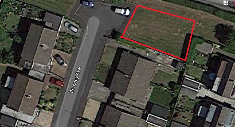
  1. Question 4 states the site is 253 sq.metres however the developeable area is considerably smaller 200 sq.metres
  2. Question 7 states that the development site is not at risk of flooding however the Environment Agency map shows that the site is at high to moderate risk of surfacewater flooding (Figure 1). 
  3.  Question 7 part 2 says the development proposes to discharge surface water to soakaway, however ground conditions here are unsuitable, there is no available watercourse to discharge to, so the only method will have to be public sewer.
  4. Question 16 on the application form describes the proposal as a 3 bedroom market value house, however the plans are for a 4 bedroom home.

Flood Risk Romsey Avenue

Design and Access Statement.

 Page 2 of the Design and Access Statement claims that "National, Regional and Local planning policy has been addressed and fully considered in the development of the proposal for the site".  This is not correct because:

Formby and Little Altcar Neighbourhood Plan policy F1 'Avoiding Increased Flooding and Flood Risk' states that "In areas at risk of flooding from any source, developments shall not lead to an increase in flooding or increased flood risk on either the application site or elsewhere within the Plan area. Where reasonably practicable, developers shall demonstrate tangible, definite and measurable reductions in flood risk and actual flooding."  The Environment Agency Flood Risk Map clearly identifies this site as at high to moderate risk of surface water flooding however the applicant has not demonstrated that development can occur without flooding to the proposed development or increasing flood risk elsewhere.

 The proposed development fails to comply with Sefton Council's newly adopted 'New Housing' Supplementary Planning Document 2018 (SPD) minimum distances between dwellings designed to protect residential amenity. The distance between the rear bedroom of the proposed property and that of the adjacent house is 17m, 4m short of what is required.

The proposal is contrary to Sefton Local Plan Policy EQ2 Design. Development will only be permitted where:

  • Part 1(a) The proposal responds positively to the character, local distinctiveness and form of its surroundings.
  • Part 2. In relation to site design, layout and access: (b) Integrates well with existing street patterns.
  • Part 3. In relation to the design of buildings and structures: (a) Proposals make a positive contribution to their surroundings through the quality of their design in terms of scale, height, form, massing, style, detailing...

Structure too high:

The proposed development of a large two storey 4 bedroom home sits at the end of a row of bungalows. The pitch of the existing properties roofs are much less steep than the proposed development and the new building would have a significantly higher ridgeline than its neighbours’ should the development to go ahead.  

Scale and style of to the development overbearing:

The scale and form of the building with an additional gable on the front facade is overbearing and dominates the street scene. The choice of black aluminium window frames, doors and ‘k-render’ dormers will give extra emphasis to the substantially greater volume of this building compared to its modest neighbours.

Loss of amenity Gardens overlooked and overshadowed.

The side and rear elevation will dominate the view from rear gardens of the near neighbours as the building juts out beyond the rear building line and the three adjoining gardens will be significantly overlooked. Sefton New Housing SPD requires a distance of 10.5m from the new dwelling to the rear fence to avoid loss of amenity from overlooking, this development only provides 7m.  

Parking provision insufficient for the size of development and incompatible with the street scene.

The existing bungalows, with which the proposal seeks to fit in, all have parking to the side of the properties and not directly in front, unlike the proposed design. Document DC_2019_02117-LOCATION__SITE_AND_PROPOSED_PLAN__01_-2076660.pdf shows parking across the front of the doorway, side on to the street scene which is out of character with the neighbouring properties. Two spaces are required as specified in Formby and Little Altcar Neighbourhood Plan Policy H6: Off-Road Parking: All new dwellings must provide off-road parking spaces and those of 2 bedrooms and above must provide off-road parking for at least 2 cars. The Department Of Transport (DoT) Manual for Streets sets a minimum parking space as 4.2m by 2.4m however many family car lengths are in excess of 4.5m and Multi Purpose Vehicles (MPV ‘People Carriers’) are often over 5m long. Sports Utility vehicles (SUV’s) are similarly around 5m long. As the property is clearly appropriate for a larger family, greater provision is necessary to provide a practical place for parking. Even at its widest, the area in front of the proposed development may leave less than a metre clearance between car and house/window when parking a larger family vehicle. At its narrowest the front curtilage of the development is not deep enough for the minimum required DoT 4.2m long parking space.

More errors in the Design Statement.

Page 3 paragraph 2 of the Design and Access Statement is misleading, incorrectly describing the proposal as a 3 bedroom detached dwelling when it is in fact a 4 bed detached home.

Level access unsiutable for flood risk areas.

Page 4 paragraph 2 says  “The proposed landscaping for the access driveway will be paving sets to the front drive way area, suitable for wheelchair users and with level access to the front entrance and to the garden area”.  However given the risk of surface water flooding in order to protect the property from surface water this may require an elevated finished floor level, potentially raising the ridge height of the property still further. Raising the surrounding ground level to allow for a level access will increase the likelihood of flooding elsewhere. This again is contrary to policy EQ8 of Sefton’s Local Plan and Policy F1 of Formby and Little Altcar Neighbourhood Plan.

National Planning Policy Framework Chapter 12 Achieving well-designed places para 130 says that “Permission should be refused for development of poor design that fails to take the opportunities available for improving the character and quality of an area and the way it functions, taking into account any local design standards or style guides in plans or supplementary planning documents”.

In summary and for the reasons above this planning application is contrary to:

Nation Policy NPPF 2019 paragraph 130.

Sefton Local Plan Policies EQ 2 ‘Design’ and EQ 8 ‘Flood Risk and Surface Water’

Formby and Little Altcar Neighbourhood Plan Policy F1 Flooding and H6 ‘Off Road Parking’.

Sefton SPD 'New Housing'.

How to Submit your objections.

You can object by post.  If so please quote the Planning Application reference DC/2019/02117 and send to: 

Planning Services,Department of the Built Environment, Magdalen House, 30 Trinity Road, Merseyside, L20 3NJ.

By email send to This email address is being protected from spambots. You need JavaScript enabled to view it. once again you must incude the Application reference DC/2019/02117

Online objection form click here and follow the instructions. 

The end of the consultation period is 15th of Decemeber 2019, however Sefton Council will accept objections beyod this date.

FRAG Councillor Maria Bennett has called this application in to be heard by the full planning committee.  Residents will be able to speak out at this committee but they will require petiton.