Brackenway Planning Approval Halted!
- Details
-
Last Updated: Friday, 31 January 2020 13:44
-
Hits: 10491
Decision to Grant Planning Approval Revoked as Application Goes Back to Planning Committee
Due to delays and complications in bringing forward the Brackenway Development the final Approval Notice was never issued for this site. During this delay Formby and Little Altcar Neighbourhood Plan was adopted. Now the Development has to come back to the Planning committee where the proposal will be judged against policies in the Neighbourhood Plan.
Those involved in making Formby and Little Altcar Neighbourhood Plan all agree that the Brackenway does not comply and should now be refused. Formby Parish Council are seeking professional representation to put in an objection to the development and represent Formby residents at the subsequent planning committee hearing.
Residents can resubmit their objection and they should include the new policies in Formby and Little Altcar Neighbourhood Plan. You may choose any policy you feel relevant to your concerns, however we have listed some that we feel are particularly relevant. Don't let this deter you from choosing others (our comments are in green this isn't part of the policy text)!
Policy H5: Storey Height
To prevent harmful incursions into Formby’s very flat, low-lying landscape, housing development above 2.5 storeys and/or the raising of the land surface significantly above its natural level will not be supported unless it can be demonstrated that such development is appropriate in its context and that no harm to local character or residential amenity will arise.
(The proposed development site will have to be raised 1.5m, that is nearly 5 foot above current levels and this is before houses are built on top. The surrounding land it notable for being flat and low lying. This will harm local character and residential amenity).
Policy H2: New Housing
Proposals for new housing must ensure that the new homes are well connected both within the site and with the wider town.
Good connections may be achieved by providing:
a) short, direct routes for pedestrians and cyclists connecting the new development to the rest of the town. This may include upgrading existing routes that connect to the development to make them attractive and safe for pedestrians and cyclists.
(Pedestrian and cycling linkages are poor with only limited connections to the neighbouring estate, not very porous to walkers and cyclists.
b) good access to local transport, by locating development as close as possible to existing bus routes and providing good pedestrian access to bus stops
(The Developer will not finance any new bus link to this site, and as this is an edge of town housing development distances to amenities are considerable).
c) good connections within the development area itself, so a choice of connections to the wider town is provided.
Policy H4: Housing Mix
New housing developments should provide a mix of different housing types.
Schemes of 15 or more dwellings shall make appropriate provision of homes for elderly people.
To meet the Neighbourhood Area’s need for smaller homes, as demonstrated through the plan making process, new developments of 15 or more dwellings should be based around the following mix:
a) 1 and 2 bed properties, no less than 33% of the total;
b) 4 or more bed properties, no more than 15% of the total.
(Currently the proposed housing mix does not meet those set out in the Neighbourhood plan, this is very different to that set out in Sefton's Local Plan).
Policy ESD2: High Quality Design
To achieve high quality design, development should make a positive contribution to local character and proposals should demonstrate consideration of the following:
a) Scale, density, height, landscape, layout, materials, access, frontages, and residential amenity.
b) Retaining or creating good quality boundary and gateway features.
c) Safety of movement and circulation of walkers, cyclists, vehicles and people with limited mobility/disability, both within and to/from the site.
d) The outlook towards, within and from the development.
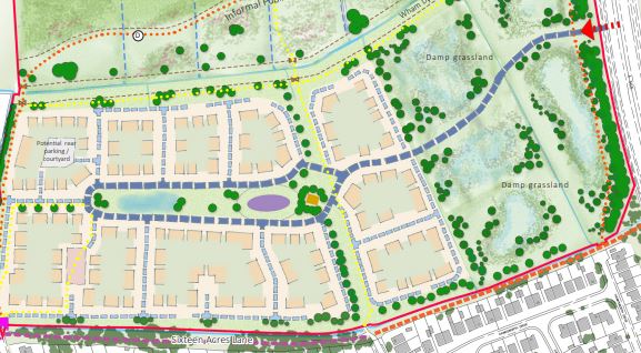
e) The delivery of high-quality green infrastructure including accessible open space commensurable with the scale of development and consistent with Local Plan policy EQ9.
(The ammenity space not only falls short of the amount required in Sefton's Local Plan but it is not high quality as demanded by the Neighbourhood plan. It is described as damp grassland. Residents in Formby will have plenty of experience of that)!
Policy ESD6: Green Infrastructure
New developments must be committed to the delivery and maintenance of high-quality green infrastructure including accessible open space commensurable with the scale of the development and consistent with Local Plan policy EQ9. Smaller developments as defined by EQ9 should provide appropriate mitigation. Developers should refer to the SPD open spaces.
The Neighbourhood Plan acknowledges the need to mitigate for any impacts of additional recreational pressure from residents of new homes on the integrity of internationally important nature sites especially those on the Sefton coast by redirecting recreation away from these fragile sensitive areas. (SPD open spaces and LP NH2).
(As the comment made above with the added point that amenity space is crucial to relieving pressure on our internationally important nature sites).
Policy F2: Flood Risk Assessments and Scheme Design
In accordance with Government guidance, planning applications in areas at risk of flooding shall be informed by a site-specific Flood Risk Assessment (FRA) demonstrating how all sources of flood risk will be managed now and over the lifetime of the development (taking into account, for example, climate change).
Whether as part of the FRA or otherwise, scheme designs shall address the requirements of the Plan’s flooding policies. They shall identify effects on all elements of the drainage system including, but not limited to, foul and surface water sewers, watercourses, water bodies and groundwater.
(The Developers Flood Risk Assessment failed to model the affect an increase in watertable (groundwater) due to climate change would have on their flood mitigation scheme and how ground raising might affect existing groundwater levels).
Policy F3: Reduced Surface Water Discharge
Developments shall seek to maximise reductions in surface water run-off as compared with the pre-development situation. Designs shall also lead to a reduction in the speed at which surface water discharges from the site.
(Most of our fields around Formby flood at normal farmland drainage rates, this actually acts as a form of natural flood protection. The new development does not maximise reductions in runoff rate, this increases the likelihood of flooding elsewhere).
Policy F4: Attenuation Areas
Development will not be permitted in flood attenuation areas where the development would reduce the ability of the area to alleviate flooding.
(The Development site is in the flood plain, permanently re profiling the land will limit the ability of this land to alleviate flooding, fixing its ability to contribute at current climate change predictions).
You can view the application and new documents at the Sefton Council Website
here.
You can email your objection to This email address is being protected from spambots. You need JavaScript enabled to view it..
Or send objections to: Planning Services, Department of the Built
Environment, Magdalen House,30 Trinity Road, Merseyside, L20 3NJ.
Don't forget to include the application number DC/2018/00093.